
Professional Land Surveyors
Hamilton • Burlington • Oakville • GTA
Survey Inquiry905-643-6131
Get a Quote
Hamilton • Burlington • Oakville • GTA

Hamilton • Burlington • Oakville • GTA
When it comes to developing, renovating, or altering a property in Ontario, what happens underground—and exactly where the water flows on the surface—is just as critical as the architectural structures you build above it. A Site Grading Plan is a specialized engineering and surveying document designed to deliberately orchestrate the movement of surface water away from buildings and safely into municipal storm systems, protecting your investment and maintaining harmony with neighboring properties.
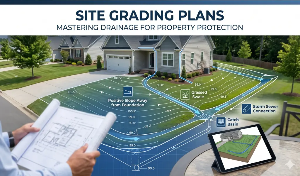
Southern Ontario experiences significant, sometimes drastic weather fluctuations, ranging from rapid spring thaws that melt heavy snowpacks to intense, sudden summer downpours. Without a professionally calculated Site Grading Plan, your property is highly vulnerable to water accumulation. Poor drainage is the leading cause of flooded basements, cracked structural foundations, and severe soil erosion that can wash away expensive landscaping.
Furthermore, property ownership comes with strict legal responsibilities. If your landscaping, paving, or new construction redirects water onto a neighbor’s lot, causing damage or pooling, you can be held legally liable for the resulting costs and repairs. A well-executed grading plan ensures that the land is contoured at highly specific slopes—usually expressed as percentages—to confidently guide water away from vulnerable foundation walls. It acts as an invisible, preventative shield, preserving the structural integrity of your home or commercial building for decades into the future.
Municipalities across the Greater Toronto and Hamilton Area (GTHA) rigorously enforce strict property standards regarding water runoff. Building departments and local by-law officers will generally require you to submit a formal Site Grading Plan in the following development scenarios:
Building a new structure inherently changes the permeability of the lot. Municipalities require absolute proof that the new footprint won't disrupt the established drainage patterns of the wider neighborhood.
Expanding your home's footprint or adding an accessory structure like a laneway suite requires a revised grading strategy, which must be approved alongside your Site Plans.
Excavating a pool displaces a massive volume of earth and severely alters the backyard's ability to absorb rainwater naturally, making a grading plan an essential component for securing a pool permit.
Significant changes to the landscape that require the installation of retaining walls must be professionally evaluated to ensure they do not trap water or eventually compromise slope stability.
Creating an effective and compliant grading strategy is a multi-step process that demands mathematical precision at every single stage. It begins with a comprehensive Topographic Survey. Our field crews physically measure the existing elevations of your lot, mapping out every subtle rise, dip, mature tree, and existing structure. This provides the crucial "before" picture for the engineering process.
Next, we design the "after" picture. Working closely with architectural designs and local municipal guidelines, our team calculates the precise slopes required to ensure water drains safely toward designated catch basins, swales, or the municipal street, without negatively impacting any adjacent lands. We establish the proposed elevations for critical points, including the top of the foundation wall, the garage floor, and the outer corners of the lot.
At Lejan Land Surveying, we utilize advanced robotic total stations and high-precision GPS technology to map your land. By capturing hundreds of exact data points, we generate highly accurate 3D surface models. This technological edge ensures our grading calculations are flawlessly precise, completely removing the guesswork for the heavy equipment contractors who rely on our plans to physically shape the landscape.
Finally, once construction is complete, municipalities almost always require a final Lot Grading Certificate. We return to the site to conduct a post-construction survey, verifying that the contractor actually moved the earth and poured the concrete precisely according to the approved plan. This final legal certification is usually mandatory before the city will agree to release your grading deposit or grant final residential occupancy.
In regions like Hamilton, Burlington, and Oakville, properties often fall under the overlapping jurisdiction of local conservation authorities, such as Conservation Halton, the Hamilton Conservation Authority, or the TRCA. If your property is located anywhere near a natural ravine, a recognized flood plain, or a designated watercourse, your grading plans will face an extra, rigorous layer of environmental scrutiny. Our surveying team possesses the deep local expertise required to navigate these highly complex regulatory environments smoothly, ensuring your plans meet both the municipal building codes and the strict environmental conservation standards, saving you from costly project delays.